 Friday, July 26, 2024
  Friday, July 26, 2024
Got news? Next submission deadline is Friday at 5:00 p.m.
Click here to submit YOUR news

With the effects of climate change becoming all the more prominent, the provincial government is spending just under $1 million to study and prepare for large-scale floods.
“These flood risk maps will enable the Department of Municipal Affairs and Environment to identify areas to be impacted by climate change as well as associated flood alert levels,” read a statement from the Department of Municipal Affairs.
“They will also show flood hazard areas along with depth and speed of water which will assist in the work of first responders.”
In late September, the province approved three plans.
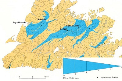
A $378,146 contract was awarded to Wood PLC for a flood risk map for the Humber Valley. The study will map along the river from around Reidville to the mouth of the river in the Bay of Islands. Wood PLC will forecast flood potential for the entire area, as well as modelling river ice.
The goal is to for the government to be able to know how floods will behave when they occur, in an effort to help inform residents in the areas.
Elsewhere, $384,050 will be paid to Hatch Engineering for a study along the Exploits River. The map will cover the river as it weaves through Badger, Rushy Pond, Grand Falls-Windsor, and Bishop’s Falls. There will also be updates to the Badger Ice Progression Model, with plans for a real-time flood forecasting model in the area.
After major floods in 2003 and 2015 in Badger after ice dams forced water into the town, the updated data will help the town prepare for any future floods.
Finally, $199,967 will go to Golder Associates to study dams in municipalities across the province, and find out what would happen if any of them were to break.
The province has already studied maps across the province, recently running a full inventory of all the dams in the province. But that report didn’t take in municipal water supply dams, which the new report will address.
The province says the study of major dam breaks is pre-emptive, to allow towns to prepare in the event a major dam were to give way.
Watch our video and learn more about the benefits of joining Construction Links Network – the peer-to-peer network sharing platform for the construction, building and design community.
Press Releases | Project Updates | New Appointments | Awards & Milestones | Company News | New Products/Services | Brochures | Videos | Infographics | Blog Sharing | Events and More