 Friday, April 26, 2024
  Friday, April 26, 2024
As blogged on Concordia.ca, have you ever wondered how city planners determine where to add new bus routes or subway lines?
The answer lies in the data.
In this case, the data comes from surveys that record individual travel behaviour. This information helps planners map out the busiest, most efficient or underused routes in a city.
“We need to know all the trips that people are making, how they make those trips and for what reason,” says Zachary Patterson, a professor of geography, planning and environment at Concordia.
There needs to be a sense of how many people are going to use the infrastructure, if it’s going to relieve congestion and by how much, says Patterson.
Patterson’s work is part of Concordia’s smart cities-related research, which looks at new or re-imagined ways to develop happy, healthier cities through improved public mobility, sustainability, environmental design, clean energy design and smart technologies.
Traditionally, travel surveys are conducted over fixed telephone lines or landlines, and involve calling people up and asking them where and how they travelled in the past day. But this method, says Patterson, can leave out a lot of people, particularly “young people that often rely exclusively on cell phones.”
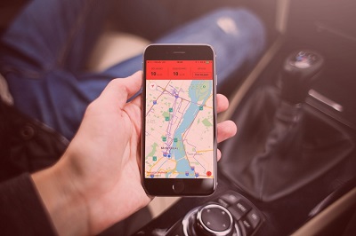
Patterson has updated the survey method for today’s smartphone users. After asking a few questions about the user’s journey, the free app passively collects data on when the user’s trip begins and ends.
“In the analyses we’ve done, we typically have an over representation of younger age-groups who are increasingly under-represented in traditional methods of data collection,” he says. “Also, the data we collect is geographically and temporally richer since we have information on itineraries in addition to just origins and destinations, which are what are traditionally collected.”
Patterson’s platform was also used to develop an app called MTL Trajet for the city of Montreal, which allows a user’s travel data to be collected with minimal effort and has been an integral part of the city three-year smartphone travel study.
After answering a survey about the user’s journey, the free smartphone application then detects when the user’s trip begins and ends if it is left running, making it a more passive way of collecting data.
Watch the video and learn more about Construction Links Network – the peer-to-peer network sharing platform for the construction, building and design community.
Ideal for YOUR Press Releases | Project Updates | New Appointments | Awards & Milestones | Company News | New Products/Services | Brochures | Videos | Infographics | Blog Sharing | Events and More