 Friday, April 19, 2024
  Friday, April 19, 2024
GIS and AEC professionals are finding new ways to collaborate and share data, thanks to some recent software rollouts. Much of the impetus stems from a partnership between industry heavyweights Esri and Autodesk, which first joined forces in 2017 to integrate their respective technologies. That partnership continues today.
ArcGIS GeoBIM
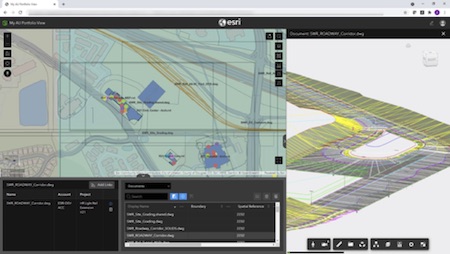
Esri officially released its ArcGIS GeoBIM, in early October, designed to help BIM project teams benefit more fully from GIS data and processes. Previously introduced as a beta version to a handful of customers, ArcGIS GeoBIM provides a web-based platform for AEC teams to collaborate using data from multiple systems in a geospatial context. The product connects to Autodesk BIM Collaborate Pro, a cloud-based design collaboration, coordination, and model co-authoring product built on the Autodesk Construction Cloud.
The ability to integrate and visualize project data in a single, cloud-to-cloud process helps users access current data more seamlessly, according to Anthony Renteria, Esri’s Product Manager for ArcGIS GeoBIM. “You’re working with live links to cloud-source data,” he explained. As BIM updates are made, the linked information viewed in a GIS environment is automatically updated. In the past, users importing BIM data into a GIS environment would have to re-import data if BIM updates were made.
Users can also be more selective in bringing data into GIS, focusing on specific types of data or geographical areas, said Renteria. “It’s a more flexible model,” he said.
From Autodesk’s perspective, the Esri partnership and resulting products help customers design and build more sustainable urban environments and infrastructure, according to Theo Agelopoulos, Autodesk’s senior director for architecture, engineering, and construction. “Our customers need GIS data to create accurate context for the things they’re designing and making,” he said.